Description
Navionics comprehensive electronic navigation charts provide the most up-to-date cartography and navigation data for boaters across the globe.
Derived from multiple official, government and private sources, Navionics cartography seamlessly combines offshore and inland content, offering clear, reliable cartography for the widest range of chartplotter brands (chartplotter compatibility can be checked at Navionics.com).
The Platinum+ cartography combines premium marine content on oceans, major rivers and seas with freshwater inland mapping for more than 42,000 lakes worldwide.
This product is supplied as a microSD card for easy installation on compatible marine devices. Once activated, the user will enter a one-year, renewable subscription, enabling access to daily updates and advanced features. For full subscription details, please see the downloadable PDF or visit the Navionics website.
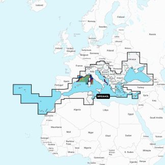
– Type: Platinum+
– Region code: NPEU643L
– Coverage areas: Mediterranean & Black Sea
– Coverage includes: the Azores, Madeira, the Canary Islands, Gibraltar, the Balearic Islands, Corsica, Sardinia, Sicily, Malta, Crete, Cyprus, the Dardanelles, the Bosporos, the Sea of Azov, the Dneiper River to the Kyivs’ke Reservoir, the Danube River to Passau, Germany, Lake Balaton, Lake Garda, Lake Como and Lake Maggiore. Ports include Cadiz and Barcelona, Spain; Monaco; Marseille and Toulon, France; Genoa, Naples, Taranto and Venice, Italy; Istanbul, Turkey; Odessa, Ukraine; Tunis, Tunisia and Algiers, Algeria.
Platinum+ chart functionalities:
• Relief Shading: The Navionics relief shading feature brings bottom detail to life, from shallow flats to deep offshore canyons, in a vivid, colourful representation that helps boaters gain a better understanding of bottom topography
• Satellite Imagery With Sonarchart™ Shading Overlay: Created from SonarChart 0.5 metre contour data, varying shades of blue reveal changes in depth such as channels and drop-offs. This improves situational awareness and gives clear, visual clues to fish-holding structure
• 3D View: Dynamic 3D View allows chart customisation to highlight key features for a better awareness of the surroundings*
• Aerial Photography: Aerial and panoramic photography of ports, marinas, bridges, docks, boat ramps, dams and navigational landmarks offers superior situational awareness
• Sonarchart™ HD Bathymetry maps: Displaying up to 0.5 metre contours for a more detailed depiction of bottom structure, for improved fishing and navigation
• Community Edits: The Community Edits content layer can be downloaded to any Navionics card allowing the user to view valuable, local information contributed by Navionics Boating app users on a compatible chartplotter
• Dock-to-Dock Route Guidance: Navionics advanced route guidance technology** uses boat settings with chart data and frequently travelled routes, to calculate a suggested path to follow from start to end point
• Sonarchart Live Mapping Feature: This feature enables the user to create their own maps on the fly and watch new 0.5 metre HD bathymetry maps develop in real time as the boat moves along the water***
• Advanced Map Options: This option allows the user to change the way they view Navionics charts and focus on details that matter to them most, such as highlighting shallow areas, adjusting contour density or selecting a fishing range
• Plotter Sync: The user can transfer routes and markers, update charts and more between the plotter card and Navionics Boating app wirelessly. The user can also activate or renew their cartography subscription and upload sonar logs
*Compatibility with 3D View varies depending on the chartplotter model
**Route guidance is for planning purposes only and does not replace safe navigation operations.
***Compatibility with Navionics advanced features varies depending on the chartplotter model.
Brand – Navionics
Weight – 0.1000
Product Type – Chart Plotter Map